
The Pacific Innovation Forum for Climate and Environment (PIFCE) 1st - 3rd July, 2026









Brief overview
DI Lab is a climate technology company specializing in AI-driven weather intelligence and climate risk analytics. The company develops advanced solutions that integrate satellite data, ground observations, and machine learning to deliver high-resolution, actionable climate insights.
DI Lab’s core platform, DICAST includes the AI Radar Map, which is designed to address critical data gaps and support decision-making in climate-vulnerable regions, especially when it come to precipitation information. The company works with governments, international organizations, and industry partners to strengthen climate resilience, improve disaster preparedness, and enable data-driven adaptation strategies across sectors, including agriculture and disaster risk management.

Your organisations goals
DI Lab provides AI-based climate intelligence solutions that transform fragmented weather and environmental data into actionable insights for decision-making. Its core services focus on integrating satellite observations, ground-based measurements, and advanced machine learning models to generate high-resolution, real-time climate information.
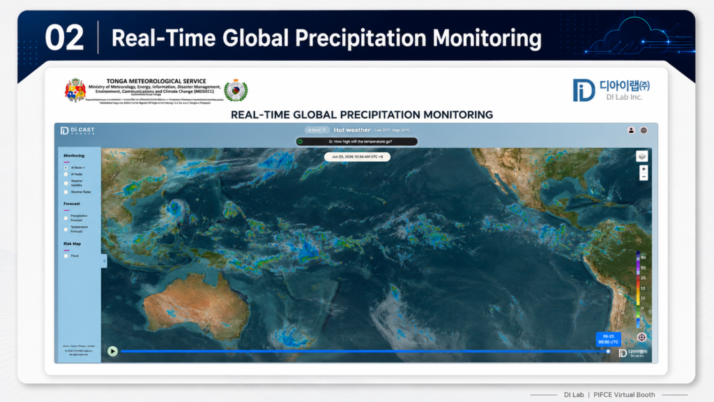
A key offering is the AI Radar Map, which produces radar-like precipitation data using satellite inputs, enabling real-time rainfall monitoring even in areas with limited radar coverage. This is particularly valuable for regions with sparse observation infrastructure, such as Pacific Island Countries and Territories (PICTs).
Complementing this is ClimaMRI, a diagnostic solution that analyzes climate risks by combining multi-source datasets to identify vulnerabilities, anomalies, and potential impacts across sectors. The platform aims to support governments and institutions in making informed decisions related to disaster preparedness, and climate adaptation.
DI Lab also provides system integration, data quality control, and capacity-building services to ensure that solutions are operationally sustainable and locally adaptable. By bridging the gap between data availability and usability, DI Lab enables stakeholders to move from reactive responses to proactive, climate-informed decision-making.
Describe your innovation
One of DI Lab’s key innovations is the integration of its AI Radar Map and ClimaMRI platforms to deliver both real-time monitoring and precision climate intelligence. The AI Radar Map uses satellite data and machine learning to generate high-resolution precipitation information in near real-time, effectively replicating radar capabilities in regions where physical radar infrastructure is limited or unavailable. This addresses a critical challenge in many Pacific Island Countries and Territories (PICTs), where geographic dispersion and high infrastructure costs make traditional radar deployment difficult.
ClimaMRI complements this by serving as a precision diagnostic tool, enabling users to assess exactly where, how, and to what extent climate risks will impact their operations. By analyzing both historical and real-time datasets, it identifies localized vulnerabilities, anomalies, and risk patterns. Rather than providing generalized climate information, ClimaMRI delivers tailored, context-specific insights, allowing governments, industries, and communities to make targeted and informed decisions.
A key feature of the solution is its emphasis on customization and localization. The platform is designed to be adapted to each country’s specific climate conditions, data availability, and operational needs, ensuring that outputs are directly relevant and actionable for end users. This is particularly important in PICTs, where climate risks and data environments vary significantly across islands.
Together, these systems support a wide range of climate-related challenges, including flood risk, water resource management, and climate impacts on agriculture and infrastructure. For PICTs, where communities are highly exposed to extreme weather and sea-level-related risks, access to localized, timely, and interpretable climate intelligence is essential.
This innovation is particularly relevant to PICTs because it reduces reliance on expensive physical infrastructure while leveraging existing global satellite systems. It enables rapid deployment, scalability across dispersed islands, and seamless integration into national systems. By combining real-time monitoring with precision diagnostics and tailored solutions, the platform supports both immediate response and long-term planning, helping governments and communities strengthen resilience and make more informed, climate-smart decisions.
How is this solution is innovative?
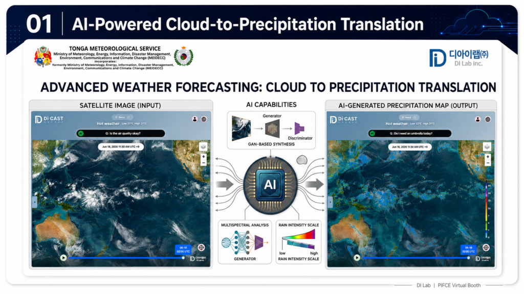
The solution is innovative in its ability to combine AI-based precipitation monitoring with diagnostic climate analytics into a unified, operational system. Unlike conventional approaches that rely on either satellite data or physical radar infrastructure, the AI Radar Map generates radar-equivalent outputs using satellite observations, overcoming infrastructure limitations in remote and island regions. ClimaMRI complements this by acting as a precision diagnostic tool, similar to medical imaging, identifying hidden risks, anomalies, and localized vulnerabilities. It moves beyond traditional data provision toward actionable intelligence, enabling users to understand not only what is happening, but why and what actions are required.
A key strength of the solution is its cost-effectiveness. In areas where traditional sensors are unavailable or difficult to maintain, the system can be supported by lightweight, low-cost IoT sensors. These require minimal maintenance while improving model accuracy, providing a practical alternative to expensive radar infrastructure. The integration of these systems enables both real-time monitoring and deeper analytical insights. Combined with its flexibility and strong focus on localization, the solution is highly adaptable across diverse environments, making it particularly suited for Pacific Island Countries and Territories.
How can the innovation be replicated and scaled up in other PICTs?
The solution is highly replicable and scalable across PICTs due to its reliance on satellite data and modular system architecture. Since it does not depend on extensive physical infrastructure, it can be deployed rapidly across multiple islands with minimal upfront investment.
Scaling can be achieved through institutional partnerships with national meteorological agencies, disaster management offices, and regional organizations. Collaboration with regional bodies and development partners can support integration into existing climate information frameworks and ensure alignment with national priorities. Subsequently, by linking with a data-driven revenue generation business model (BM),the service will secure stable revenue through subscription-based and contract-based models, ensuring sustainable funding for long-term service operation.
In addition, the service will be expanded across sectors such as agriculture, infrastructure, and insurance through public-private partnerships (PPP), driving further business growth.
Capacity-building is a critical component of scaling. Training programs for local agencies and stakeholders ensure that the system can be operated, maintained, and further developed locally. By combining technical deployment with institutional strengthening, the solution can be effectively replicated across diverse island contexts while maintaining long-term sustainability.
How is the solution cost‑effective and affordable in the context of Pacific Island Countries and Territories (PICTs)?
The solution is designed to be cost-effective and affordable, particularly in the context of PICTs where financial and infrastructure constraints are significant. By leveraging satellite data and AI models, it eliminates the need for for extensive nationwide radar installation, reducing operational expenses, while still enabling full territorial coverage.
For end users such as local governments, communities, and MSMEs, the system provides high-value climate information without requiring significant upfront investment. During initial deployment phases, access can be supported through public funding or development programs, ensuring that critical information is available as a public good.
Over time, cost-sharing and subscription-based models can be introduced for institutional users, while maintaining affordability through tiered pricing structures. The system’s ability to improve decision-making—such as reducing crop losses, optimizing resource use, and enhancing disaster preparedness which translates into economic savings that outweigh the cost of the service.
This makes the solution not only affordable but also economically beneficial for end users, particularly in vulnerable and resource-constrained island settings.
Locations (country, island, or community) where this solution has been piloted and/or implemented
The solution is currently being piloted in Tonga, where a Proof of Concept (PoC) is underway in collaboration with the Tonga Meteorological Services (MEIDECC). This pilot focuses on localizing the AI Radar Map for the Tongan context by integrating data from the country’s newly installed weather radar system.
The objective is to enhance precipitation monitoring accuracy and develop a system that reflects local climatic conditions and operational needs. This effort is particularly significant given Tonga’s geographic characteristics as a small island nation with high exposure to extreme weather events. By combining radar data with satellite-based AI analysis, the project aims to improve real-time rainfall monitoring and strengthen early warning capabilities.
In addition, the solution is being piloted in the agriculture sector in Indonesia, where its applications are being tested for optimizing irrigation and managing climate risks such as floods and landslides. This includes collaboration with a private-sector partner operating palm oil farms, where localized precipitation intelligence is being used to support more efficient and climate-resilient operations.
In addition to Tonga, the solution is also being currently piloted in the Philippines in collaboration with PAGASA, where it is being adapted for national-scale precipitation monitoring and climate information services. These pilot implementations demonstrate the solution’s adaptability to both island and archipelagic environments, supporting its scalability across Pacific Island Countries and Territories.