Developed by the Vanuatu Public Works Department/Van-KIRAP Project
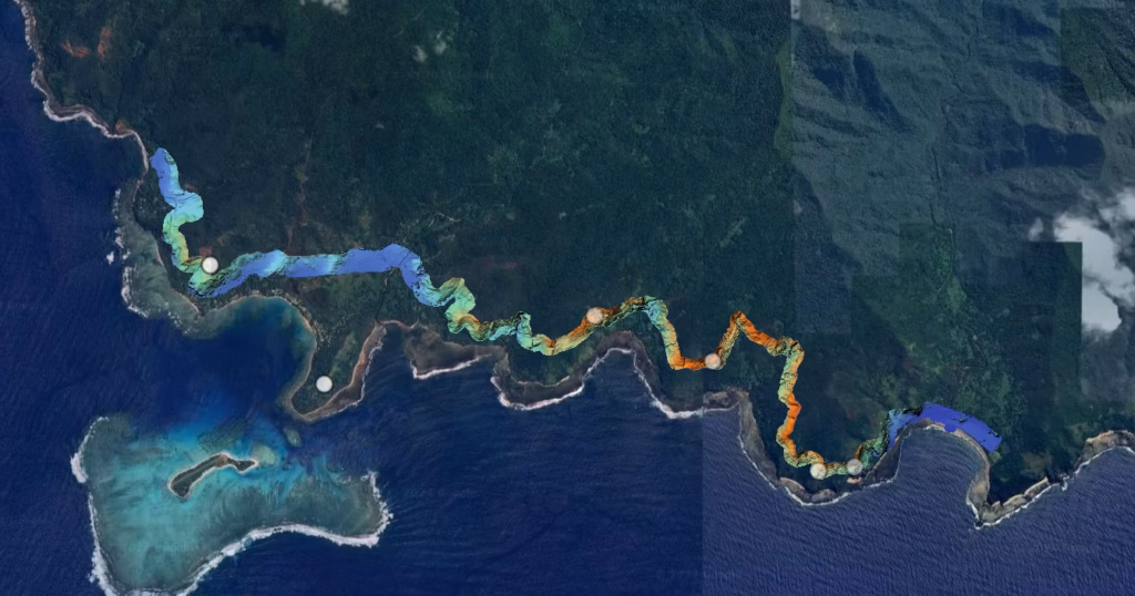
We are leveraging the Matrice 300 RTK drone equipped with L1 LiDAR and P1 photogrammetry cameras to enhance climate-resilient infrastructure in the Pacific. This innovation allows us to conduct high-precision aerial surveys, monitor coastal erosion, assess infrastructure vulnerability, and optimize designs for roads, bridges, and drainage systems.
With rapid data collection and real-time mapping, we can respond proactively to rising sea levels, extreme weather events, and shifting environmental conditions, ensuring sustainable development tailored to the unique challenges of the Pacific region.
Adaptation to Sea Level Rise: The drone’s aerial capabilities help monitor and design coastal defences tailored to low-lying islands.Building Climate-Resilient Infrastructure: Data-driven infrastructure planning, such as climate-proof bridges and roads, ensures that investments last longer under changing environmental conditions.
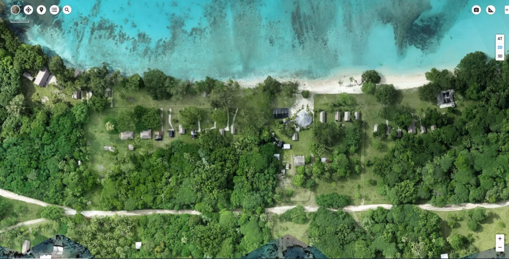
Waialo River Road Crossing: Understanding the profile by developing DEM for decision making
Aneityum Road Scoping: Identifying road alignment and proposed road crossing with Lidar data
Lonnoc Beach: Assessing coastal change of the area for Tourism purposes
Isangel-Lenakel: High Resolution orthomosaic map of the area
About
Abyss Vanuatu Ocean Institute (AVOI) delivers integrated, science-led services focused on marine restoration, climate resilience and sustainable environmental management. Its core services include the design and deployment of Reef Ball artificial reef systems and managed vessel reefs to restore degraded marine habitats, enhance biodiversity and support fisheries recovery. AVOI also provides drone-enabled monitoring and survey services, using autonomous and manned systems to track climate impacts, support conservation planning and improve data-driven decision-making across marine and coastal environments.
A central component is the development of the Vanuatu Ocean Rangers program, which builds local workforce capability in restoration, monitoring, conservation and environmental stewardship. AVOI also supports Marine Protected Area (MPA) design, ecological baseline assessments and long-term monitoring frameworks aligned with national ocean policy objectives.
Through community engagement, eco-tourism integration and applied innovation, AVOI connects environmental protection with economic opportunity. Its Havannah Harbour pilot serves as a scalable model to deliver practical climate adaptation, strengthen ecosystem resilience and enable coordinated, whole-of-government environmental outcomes across Vanuatu.
The Innovation
One of AVOI’s key innovations is the integration of the Vanuatu Ocean Ranger program with locally delivered marine restoration systems, including Reef Ball fabrication and deployment. This model combines workforce development, community engagement and practical restoration into a single, scalable framework designed for island environments.
Through structured Vanuatu Ocean Ranger Camps, over a 3 day period AVOI identifies and trains local Ni-Vanuatu participants in marine conservation, Scientific diving, restoration techniques, monitoring and stewardship. One aspect of the Rangers responsibilities is to support the fabrication and deployment of Reef Ball artificial reef systems using locally sourced materials and regional supply chains, significantly reducing costs and increasing local ownership. The approach enables degraded reef systems to be restored while simultaneously building in-country capability and employment pathways, guided by our National AVOI Play Book at its core.
This innovation directly addresses climate change by strengthening reef resilience, supporting fisheries recovery and enhancing coastal protection against storm surge and extreme weather events. It also improves ecosystem health, which is critical for food security and long-term adaptation in Pacific Island Countries and Territories (PICTs).
What makes this model particularly relevant for PICTs is its practicality and scalability. It does not rely on high-cost external inputs but instead builds local capacity, integrates customary stewardship and aligns with government policy frameworks. The system can be replicated across islands using a consistent training, deployment and governance approach.
Supported by drone-enabled monitoring and AI self learning data collection, AVOI’s model provides a cost-effective, community-led solution that connects restoration, climate resilience and sustainable economic opportunity in a way that is both locally grounded and nationally scalable.
How is this solution innovative?
AVOI’s solution is innovative because it integrates community workforce development, marine restoration and applied technology into a single, scalable delivery model tailored for island environments. Rather than treating conservation, employment and climate adaptation as separate challenges, AVOI combines them through the Vanuatu Ocean Ranger program and locally delivered Reef Ball restoration systems. This creates a practical pathway where communities are directly trained and employed to restore and monitor their own marine ecosystems. The model also incorporates drone-enabled monitoring and emerging AI-supported survey systems to improve data collection, ecological tracking and rapid response capability, including in remote and disaster-affected areas. This blend of low-cost, locally sourced restoration methods with advanced monitoring technology allows for both accessibility and scientific rigour. What makes the approach particularly innovative is its focus on scalability and replication. By developing a standardised training, deployment and governance framework, AVOI provides a repeatable model based on a National AVOI Play book that can be adapted across Pacific Island Countries, helping translate policy into measurable, community-led climate and environmental outcomes.
How can the innovation be replicated and scaled up in other PICTs
AVOI’s model is designed for replication across Pacific Island Countries and Territories (PICTs) through a structured, partnership-driven and capacity-focused approach. Following an initial two-year proof-of-concept in Vanuatu, AVOI will develop a refined National PICT Playbook outlining standard operating procedures (SOPs) and safe work method statements (SWMS), delivered in both English and Bislama, with visual and pictorial elements to ensure accessibility across diverse communities.
Scaling will be enabled through institutional partnerships with government agencies, regional bodies, scientific partners such as UTS, and local stakeholders, supported by blended financing models including public-private partnerships, eco-tourism revenue streams and conservation funding.
A key component is the development of a simplified, citizen science-based survey framework focused on key indicator species. This approach lowers technical barriers, enabling participation from communities with varying levels of formal education while strengthening data collection and stewardship.
By combining local workforce training, accessible science, and standardised systems, AVOI creates a practical, low-cost model that can be adapted regionally, empowering communities while supporting climate resilience, biodiversity restoration and sustainable economic development across PICTs.
Is your solution cost‑effective and affordable in the context of Pacific Island Countries and Territories (PICTs)?
AVOI’s solution is designed to be highly cost-effective and affordable for communities, local governments and small operators across PICTs. A core principle of the model is the use of locally available materials, including aggregates from regional quarries and, where appropriate, surplus or repurposed government materials. This significantly reduces construction and deployment costs for Reef Ball systems and associated infrastructure.
From an end-user perspective, the model lowers financial barriers by building local capability through the Vanuatu Ocean Ranger Camp Initiative and subsequent program, reducing reliance on external expertise and enabling communities to deliver and maintain restoration activities themselves. The integration of eco-tourism also creates revenue-generating opportunities that can help offset ongoing costs.
Affordability is further strengthened through the development of a streamlined cross-departmental approval pathway within the AVOI Playbook. By providing clear guidance on site selection, environmental considerations and standardised processes, local governments can reduce delays, duplication and administrative costs, enabling more efficient project delivery at scale.
Together, these elements create a low-cost, accessible and sustainable model that is practical for widespread adoption across PICTs.
Where is this being piloted?
AVOI’s solution is being piloted in Vanuatu, with Havannah Harbour (North-West Efate) identified as the primary proof-of-concept site, supported by a permanent operational and training hub at Lot 149, Lapita Estate. While over 1,000,000 Reef Balls have been deployed globally across more than 80 countries, this will be the first integrated deployment of this system in Vanuatu. The pilot combines initial baseline surveys across 12 regions using Reef Life Survey (RLS Methodology) prior to any deployments. Once 6 of the sites are selected for deployment we will deploy 50m x 10m of Reef Ball habitat restoration—designed as a 500+ year solution—, allowing us to. Continue to conduct 6 monthly replicated surveys in exactly the same 50m transects to demonstrate recruitment changes providing proof of concept. Together with the Vanuatu Ocean Ranger program, which trains and employs local Ni-Vanuatu to deliver restoration, monitoring and stewardship, supported by drone-enabled surveying, community engagement and eco-tourism integration. The approach is intentionally holistic, linking marine restoration, climate resilience, workforce development, local supply chains and government coordination into a single, place-based model. The Havannah Harbour pilot will be used to refine systems, demonstrate measurable outcomes and establish a scalable framework for national and regional replication across PICTs, through the development of our AVOI National Playbook, helping guide replication across all our satellite sites. Initial training will be conducted through AVOI Headquarters in Havannah Harbour, with Ranger selection conducted through a multi-day conservation camp where participant will all leave with new knowledge and appreciation for the terrestrial and marine environment, and Ocean Rangers selected for employment within the AVOI team at the conclusion of the camps.
There was a problem reporting this post.
Please confirm you want to block this member.
You will no longer be able to:
Please note: This action will also remove this member from your connections and send a report to the site admin. Please allow a few minutes for this process to complete.