Developed by The Pacific Community (SPC).
What is the innovation?
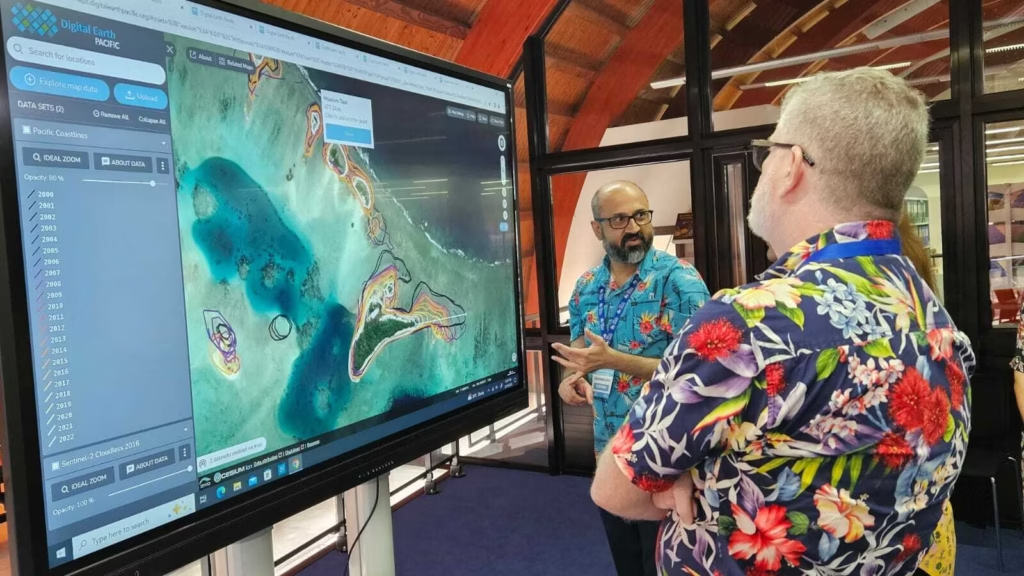
The Pacific Community’s (SPC) Digital Earth Pacific (DE Pacific) programme is a free digital public infrastructure that delivers Earth and marine observation systems, harnessing decades of satellite data to monitor environmental changes across the Pacific region. By providing accessible and regularly updated data, DE Pacific enables Pacific Island leaders and communities to make better-informed decisions on critical issues such as climate change adaptation and resilience, disaster preparedness, and sustainable resource management.
The platform offers free and open products and services, ensuring that all member states have the tools and technologies necessary to monitor their needs routinely. Currently, DE Pacific offers three products:
- Pacific Coastline Changes: Monitors coastline changes across Pacific Island countries and territories since 2000, providing insights into erosion and land accretion to support coastal development planning and hazard risk analysis.
- Water Observation From Space (WOFS): Provides an annual summary of where surface water is present across landscapes, using satellite data since 2013 to monitor changes and visualise water patterns over time.
- Pacific Mangroves Change Detection: Maps mangrove ecosystems across Pacific Island countries and territories, classifying them by density to support carbon monitoring, biodiversity mapping, and shoreline protection initiatives.
An SPC programme, DE Pacific is co-created with the communities and members it serves, ensuring that it directly addresses their most urgent needs. It helps us achieve our 2050 Leaders vision for our Blue Pacific Continent and underpins the progress towards the Paris Agreement and Sustainable Development Goals.
How does this innovation resolve Pacific-related challenges?
Digital Earth Pacific is an innovative initiative tailored to the unique challenges of the Pacific Island region. It is designed specifically with the Pacific’s unique geographical and environmental challenges in mind; empowering island nations to build resilience against different threats such as climate change, environmental degradation, and disaster risks, making it a critical tool for sustainable development and regional adaptation efforts.

Case studies
Monitoring mangroves following TC Winston
Severe Tropical Cyclone Winston made landfall on Viti Levu, Fiji, on 20 February 2016 as a category 5 cyclone. With peak intensity, ten-minute sustained winds of 280 km/h (170 mph), it was one of the strongest landfalls worldwide.
Winston brought widespread damage with entire communities destroyed. A total of 44 people were killed across the nation, and an additional 126 were injured. An estimated 350,000 people – the nation’s total population was 837,721 as of the 2007 census – were affected by the storm.
Tropical cyclones are also recognised as significant drivers of change in mangrove ecosystems (Lugo, 2000). In Fiji, it is estimated that 77% of mangrove cover loss between 2001 and 2018 can be directly attributed to the successive impacts of Tropical Cyclones Gene, Mick, Evan, and Winston (Cameron et al., 2021). The DE Pacific mangrove data for Viti Levu Bay, Fiji, for the year 2016, when TC Winston hit the area, shows large areas classified as ‘open mangroves’ (light green) or ‘no mangroves’ (grey), potentially indicating damage to the mangrove canopy cover caused by the cyclone.
Detecting drought with WOFS
Papua New Guinea is vulnerable to several hazards, including floods and droughts. Some of these are expected to increase in frequency, magnitude, and intensity due to climate change. The El Niño Southern Oscillation (ENSO) phenomenon has already been observed to have an increasingly negative effect on PNG’s climate, triggering more intense drought and flood events.
It is widely reported that a strong drought event commenced in PNG at the beginning of 2015 and reached its peak during 2016. The drought has been attributed to a strong El Niño which occurred during these years. This strong El Niño phase was paired with a positive IOD phase; the interacting impacts of both climate drivers resulted in devastating negative rainfall anomalies across the entirety of PNG affected approximately 40% of PNG’s population, including through drought-caused food shortages (Aitkenhead et al., 2021).
The DE Pacific product ‘Water Observations from Space’ (WOFS) is an annual summary of the temporal and spatial extent of surface water over landscapes. In essence, it highlights where water is usually or where it is rarely during a given year. The areas coloured red, orange and yellow show areas where water has been sporadically detected during the year (indicating potential floodplains), while the darker blue colours indicate areas where water was detected very frequently (indicating permanent water bodies).
The product may be used for a range of applications, including monitoring surface water access and detecting intra-annual and interannual changes in water bodies over decades, including droughts, flooding, water harvesting and storage. This can be applied to monitoring reservoir levels in dams, ecological connectivity, and surface-groundwater relationships.
The flat land between the Fly River delta and the Aramia river in Papua New Guinea includes many freshwater lagoons. The depth of the water depends on the season, varying from a collection of large pools in the dry to about three metres during the wet season. These variations are visible in the WOFS dataset. However, the WOFS data for 2016 shows a significant reduction in the area and the frequency with which water was detected that year.
Tracking Coastline Change
Coastlines are changing all over the Pacific, including in the Solomon Islands, where progressive stages of island erosion in islands off Isabel Island are visible. Between the years 2000 and 2022, the size of Hetaheta (the large island) and surrounding islets have been contracting, with the detected coastlines moving steadily inwards.
Between 2018 and 2019, the easternmost point of the island became separated from the rest.