A free smartphone app for everyone, available on Android or iOS in four languages (English, French, Spanish, Arabic) for sharing testimonials and viewing maps showing exposure to hazards or events currently developing.
A CONSULT web service to analyse shared alerts, detect important events based on these shares, publish and distribute maps and messages to users of the application or users networks.
A SECURIT CHECK mass messaging service, in the form of notifications (free of charge), text messages, voice messages, and emails.
The app allows users to share reports on 27 natural and man-made phenomena. It alerts you if another user shares an alert near your major points of interest. Our suite of tools requires no infrastructure and works worldwide, anywhere with mobile phone or WiFi coverage. SIGNALERT app is the only multihazard, multilingual application for sharing information about risks and events as they happen.
Share permanent cartographic information for planning and preparing for extreme events
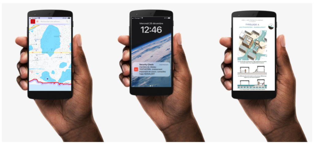
The application user can access hazard exposure maps (flood zones, coastal submersion zones or areas to be evacuated in the event of a tsunami or storm surge) for their territory, published by a regional or national authority.
The same authority can publish evacuation plans and routes for its communities, as well as permanently accessible refuge sites. The app’s main map screen allows everyone to locate themselves on these maps.
The app offers advice on how to behave in different situations in several languages, so that foreign visitors are not left feeling helpless or behind when facing a situation they have never encountered before in an unfamiliar place.
In addition to the static information available at all times, we publish daily maps of current events (cyclones, forest fires) or recent events (earthquakes, floods).
Create your community or organisation user network
You create your network of users by territory, organisation or company in order to communicate with them in a privileged manner. The geographical scale can vary from an island community to an entire country.
Issue early warning messages to communities, maps of foreseeable impacts, evacuation plans for refuge areas or shelters
The SECURITY CHECK web interface is a platform for sending SMS, voice messages and emails to a network of subscribers who wish to receive notifications from an authority such as a local council, municipality or civil protection service. Using the app to send notifications makes this method of communication completely free, unlike sending text messages.
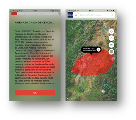
A civil protection agency can send a notification to a network of residents in a territory equipped with the application, inviting them to consult a map and instructions relating to a planned or ongoing event. The application user locates themselves on these maps and can act according to the instructions provided.
Share real-time, localised descriptions of the impact of extreme events.
The initial purpose of the SIGNALERT application is to share real-time descriptions of the impact of phenomena. The users describe what they are witnessing, their alert are geolocated, they attach photos, and they can rate the intensity of certain phenomena using intensity scales. Emergency responders are immediately informed of the location of impacts or requests for assistance.
If the application user is connected to a network associated with a territory monitoring account, the CONSULT and SECURIT CHECK tools enable communication with the user, sending them messages, requests for additional information, safety or intervention instructions, and even maps showing the location of shelters or evacuation routes.
How the app addresses climate change impacts
Among the dangers caused by climate change, the risk of coastal flooding during storms is an existential threat to certain coastlines and islands. If maps showing exposure to storm surges or areas at risk of permanent flooding are publicly available, they can be shared on the app with the communities at risk.
The application can disseminate information on possible relocation areas, approaches to strengthening buildings against flooding, or reducing erosion through nature-based solutions.
In the Caribbean, the application is used to report the stranding of Sargassum seaweed, which pollutes beaches and impacts biodiversity.
Communities at risk involved in implementing nature-based solutions can share photos from the field or measurements of the condition of structures or damage caused by storms, best practices, and solutions found to local problems.
Tools that can be adapted to your territory
The application can be adapted to display only phenomena relevant to your territory. The graphic charter can be modified and branded with your logo or left blank. New languages or vernaculars can be integrated into the application.
Our services are not intrusive, do not track you, and comply with European regulations on personal data protection. Your location is only shared when you share an alert.
Request an online demo, subscribe to the services
The smartphone app is accessible to everyone. Web services are subscribed to on an annual basis for a defined territory and for the phenomena of interest, and allow users to receive alerts, publish maps or send alert messages to user networks.
Request an online demonstration of how to use the application’s features and services for publishing maps and sending bulk messages, for you and your teams or your community.
Please note:
This action will also remove this member from your connections and send a report to the site admin.
Please allow a few minutes for this process to complete.